")
")
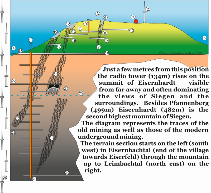
1 your location
2 radio tower (134m)
3 peak of Eisernhardt (482m)
4 Eisernbachtal, end of Eisern (south west)
5 Leimbachtel (north east)
6 Sintern pits (surface mining, up to 40m)
7 lodes (east-west)
8 example old mining in underhand stoping (top down)
9 mine shaft (as deep as 80m)
10 Einsturz gallery
11 Rader gallery
12 Birker pits
13 ore lodes (north south)
14 Haus Oranien deep bottom gallery
15 Union gallery (coming from Hengsbach)
16 Alte Birke gallery
17 Kraemer and Birker middle gallery (exact location unknown)
18 Morgenroether deep bottom gallery (deepest gallery)
19 shaft tower and shaft of former pit Eisernhardter Tiefbau (271m above sea level)
20 bottom of the shaft, depth 788m (516m below sea level)
21 example mining in overhand stoping
22 3rd stope in 200m depth – connection to pit Bruederbund
23 9th stope in 490 m depth – 2nd connection to pit Bruederbund via blind shaft of Eiserner Spies
24 14th stope in 780m depth – connection to pit Ameise in upper Leimbach valley
25 sea level
26 to reach the deepest point of Eisernhardt you’d have to bury seven radio tower one below the other
[ Schema scale: height approx.. 1:1 ; distance (2,5km) reduced to approx. 2:1 ]